top of page
  • Foto do escritoremvolpi9

Mapas pictóricos, jóias ilustradas


Uma exibição detalhada de mapas pictóricos dos mestres deste tipo de representação artística


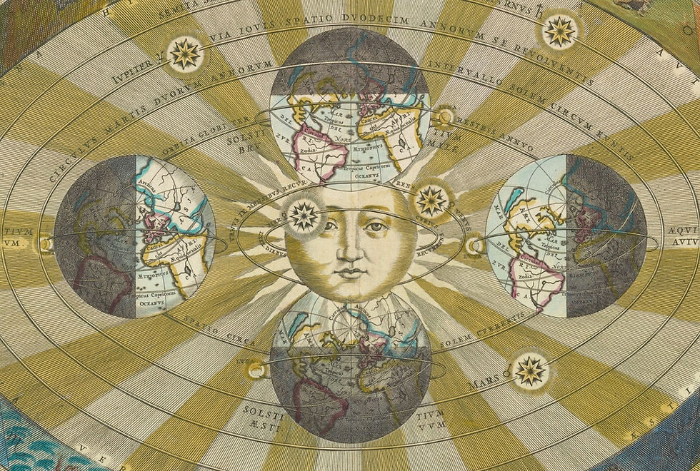
Você se lembra daqueles mapas de murais que pendiam nas paredes da escola com as matérias-primas de cada região ou com as raças do mundo? Essas representações, mais artísticas do que técnicas e que permanecem na memória coletiva com um toque de nostalgia, são um exemplo dos chamados mapas pictóricos.


Muito em voga entre 1920 e 1950, esse tipo de cartografia reaparece atualmente pelas mãos de ilustradores e designers que retomam a ideia com estilos bem decô ou com a linguagem cômica, e até oferecem versões interativas via web, como é o caso do mapa do centro da capital da Islândia, Reikiavik.


Mas a verdade é que os mapas pictóricos não são uma invenção do século 20: esse tipo de cartografia existe desde os tempos antigos no antigo Egito, na Roma Imperial, na idade Média e no Renascimento, como ilustra bem este painel do Pinterest.


Monocle Mediterraneo Map - Mike Lemanski
Mapa ilustrado de Mallorca - Vesa Sammalisto
Sur del Tirol - Martin Haake
Reykjavik Ilustrated map - Borgarmynd
Island of Oahu - Ruth Taylor White
Etna, Sicilia - Heinrich Caesar Berann
Yellowstone National Park - Henry Wellge
Mapa ilustrado de América del Norte - Miguel Covarrubias
London Theatreland 1915 - Leslie MacDonald Gill
The Voyage of the Pequod from the Book Moby Dick by Herman Melville
Brazil: A view from the southeast - Richard Edes Harisson
The Great War Map - Ernest Clegg
Lake Tahoe - Gerald A. Eddy
On To Tokyo. Map of the Pacific and the Far East - Stanley Turner
Bermuda Islands - Helen F. McMillin
Le Maroc - Lucien Boucher
Map of the World United  - Ernest Dudley Chase
Map of the World United - Ernest Dudley Chase
Grand Canyon - Jo Mora
Downtown district of Manhattan - Arthur Zaidenberg
Map of San Francisco Showing Principal Streets and Places of Interest - Harrison Godwin
Cape Cod: Barnstable County Massachusetts - Ashburton Tripp
A map of the wondrous isle of Manhattan - Charles Vernon Farrow
A map of Cape Cod - Coulton Waugh
A Scott-Map of Salem Massachusetts - Alva Scott Garfield
Robert E. Lee. 1809-1870 - Karl Smith
A map of the wondrous isle of Manhattan - Charles Vernon Farrow
New York World´s Fair 1939 - Tony Sarg
Washington D.C. Showing the Architecture and History - Blake Clark


Publicado na página Curiosidades Cartográficas do Facebook em: https://www.facebook.com/curiosidadescartograficas/posts/1848935601966632

218 visualizações0 comentário

Posts recentes

Ver tudo
Post: Blog2_Post
bottom of page